Explore the great outdoors and enjoy Lincolnshire’s scenic landscapes walking along the Viking Way. Discover the 13 sections you can walk within the historic trail in Lincolnshire.
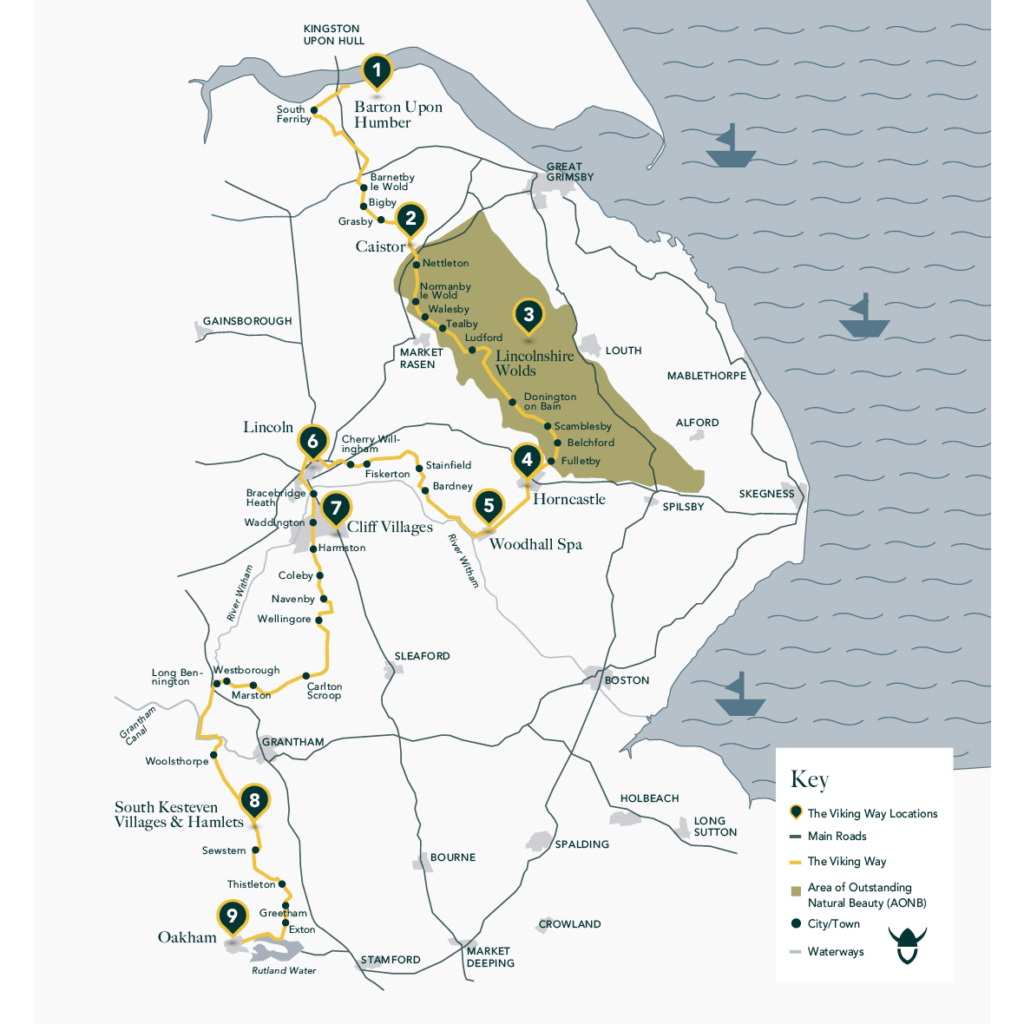
The Viking Way is a 149-mile long walking route through Lincolnshire, Leicestershire and Rutland. The route opened in 1976 and its name recognises the influence of the Norse invaders on the east of Britain. The route is clearly marked with the recognisable viking helmet on the yellow disc. The complete route can be divided into 13 separate walks or if you are looking for shorter circular walks try the Viking Way shorts which use parts of the larger route.

Sections of the Viking Way
From Barton Upon Humber in North Lincolnshire to Oakham in Rutland, The Viking Way is split into 13 distinct sections. Meandering through market towns and the Lincolnshire countryside, the 149-mile walking trail is the perfect way to soak up the county’s scenery while keeping active.
- Barton On Humber To Barnetby Le Wold Walk 14miles (22.53km)
- Barnetby Le Wold To Caistor Walk 8miles (12.87km)
- Caistor To Tealby Walk 9miles (14.48km)
- Tealby To Donington On Bain Walk 10.5miles (16.90km)
- Donington On Bain To Horncastle Walk 13.5miles (21.73km)
- Horncastle To Bardney Walk 15miles (24.14km)
- Bardney To Lincoln Walk 16.5miles (26.55km)
- Through Lincoln Walk 2miles (3.22km)
- Lincoln To Wellingore Walk 10.5miles (16.90km)
- Wellingore To Marston Walk 15miles (24.14km)
- Marston To Woolsthorpe Walk 9.75miles (15.69km)
- Woolsthorpe To Sewstern Walk 10miles (16.09km)
- Sewstern To Oakham Walk 14.25miles (22.93km)


